Foundations of Trigonometry
5. Applications of Right Triangle Trigonometry
Learning outcomes
- I can solve problems involving angles of elevation and depression.
- I can model real-world situations using right triangles.
- I can solve navigation and surveying problems.
- I can apply trigonometry to practical measurement tasks.
- I can interpret solutions within context.


Why Is Right Triangle Trigonometry Useful?
Right triangle trigonometry allows us to calculate distances, heights, and angles that may be difficult or impossible to measure directly.
Imagine trying to measure:
- the height of a tall building
- the height of a tree
- the width of a river
- the distance to a ship
- the slope of a hill
- the height of a cliff
- the distance between two locations
In many situations, we can measure one distance and one angle, construct an imaginary right triangle, and use trigonometry to calculate the missing measurement.
This makes trigonometry useful in fields such as:
- surveying
- navigation
- engineering
- architecture
- construction
- astronomy
- aviation
- mapping
Review: The Right Triangle
A right triangle contains one angle of:
90°
Relative to another angle θ, the three sides are called:
- opposite
- adjacent
- hypotenuse
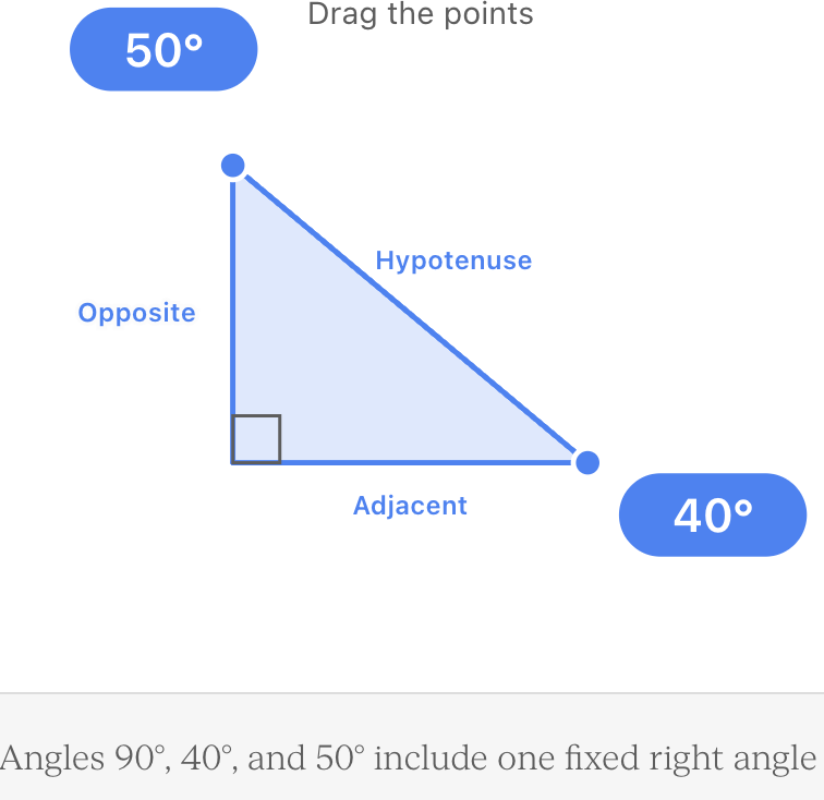
The hypotenuse is always opposite the 90° angle and is always the longest side.
The opposite and adjacent sides depend on which angle you are considering.
SOH CAH TOA
The three basic trigonometric ratios are:
SOH
sin θ = opposite ÷ hypotenuse
CAH
cos θ = adjacent ÷ hypotenuse
TOA
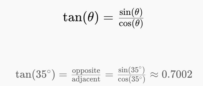
tan θ = opposite ÷ adjacent
A useful memory aid is:
SOH – CAH – TOA
Choosing the Correct Ratio
Before calculating anything:
Step 1: Identify the angle.
Step 2: Label the known and unknown sides relative to that angle.
Step 3: Determine which two sides are involved.
Step 4: Choose sine, cosine, or tangent.
| Sides involved | Ratio |
|---|---|
| Opposite and hypotenuse | sine |
| Adjacent and hypotenuse | cosine |
| Opposite and adjacent | tangent |
For many height and distance problems, tangent is particularly useful because the horizontal distance is adjacent and the vertical height is opposite.
Modeling Real-World Situations
The most important skill in applied trigonometry is often not performing the calculation.
It is recognizing the triangle hidden inside the situation.
Consider a person looking at the top of a building.
The situation contains:
- a horizontal distance along the ground
- a vertical building
- a line of sight
- an angle between the horizontal and the line of sight
These form a right triangle.


Once the triangle has been identified, the problem becomes a normal right-triangle calculation.
Angle of Elevation
An angle of elevation is the angle measured upward from a horizontal line.
Imagine standing on level ground and looking toward the top of a tower.
Your eyes begin looking horizontally.
You then look upward.
The angle through which your line of sight moves is the:
angle of elevation
Example 1: Finding the Height of a Building
A student stands 30 m from a building.
The angle of elevation to the top is:
40°
Assume the student's eye level is ignored for now.
We know:
Adjacent = 30 m
Opposite = building height
Angle = 40°
We need opposite and know adjacent.
Therefore use:
tan θ = opposite ÷ adjacent
tan 40° = h ÷ 30
h = 30 tan 40°
h ≈ 25.2 m
The building is approximately 25.2 m tall.
But What About Eye Height?
In real measurements, the angle is normally measured from the observer's eye or from an instrument above the ground.
Suppose the student's eye level is:
1.6 m
The trigonometric calculation gives the vertical distance from the student's eyes to the top of the building.
Therefore:
Building height = calculated vertical height + eye height
Building height = 25.2 + 1.6
Building height ≈ 26.8 m


This is an important example of interpreting the answer within context.
Angle of Depression
An angle of depression is measured downward from a horizontal line.
Imagine standing on a cliff and looking downward toward a boat.
Your horizontal line of sight points straight ahead.
Your actual line of sight points downward toward the boat.
The angle between these lines is the:
angle of depression


Elevation and Depression Are Related
Horizontal lines are parallel.
Therefore, the angle of depression from the observer is equal to the corresponding angle of elevation from the object.
For example:
Angle of depression = 32°
Corresponding angle of elevation = 32°
This often makes it easier to label the right triangle.
Example 2: Lighthouse and Boat
A lighthouse is:
45 m tall
The angle of depression from the top of the lighthouse to a boat is:
28°
How far is the boat from the base of the lighthouse?
Let horizontal distance = d.
Opposite = 45 m
Adjacent = d
Angle = 28°
Use tangent:
tan 28° = 45 ÷ d
Rearrange:
d = 45 ÷ tan 28°
d ≈ 84.6 m
The boat is approximately 84.6 m horizontally from the base of the lighthouse.
Drawing the Diagram First
Many trigonometry mistakes can be avoided by drawing a diagram before calculating.
Your diagram does not need to be perfectly to scale.
It should show:
- the right angle
- the known angle
- known distances
- unknown distance
- horizontal and vertical directions
- line of sight
Then label the sides:
O = opposite
A = adjacent
H = hypotenuse
Example 3: Finding the Length of a Ramp
A wheelchair ramp rises:
0.8 m
and makes an angle of:
6°
with the horizontal.
Find the length of the ramp.


We know:
Opposite = 0.8 m
Hypotenuse = ramp length
Angle = 6°
Use sine:
sin 6° = 0.8 ÷ L
L = 0.8 ÷ sin 6°
L ≈ 7.65 m
The ramp must be approximately 7.65 m long.
Example 4: Ladder Against a Wall
A 5 m ladder leans against a wall.
The ladder makes an angle of:
68°
with the ground.
How high up the wall does the ladder reach?
Known:
Hypotenuse = 5 m
Opposite = h
Angle = 68°
Use sine:
sin 68° = h ÷ 5
h = 5 sin 68°
h ≈ 4.64 m
The ladder reaches approximately 4.64 m up the wall.


Example 5: Finding a Distance
A person observes the top of a tower at an angle of elevation of:
35°
The tower is:
50 m high
How far is the person from the tower?
Opposite = 50 m
Adjacent = d
tan 35° = 50 ÷ d
Therefore:
d = 50 ÷ tan 35°
d ≈ 71.4 m
The observer is approximately 71.4 m from the base of the tower.
Finding an Angle
Sometimes the sides are known and the angle is unknown.
This requires an inverse trigonometric function.
Suppose:
Opposite = 20 m
Adjacent = 35 m
Then:
tan θ = 20 ÷ 35
tan θ ≈ 0.5714
Use inverse tangent:
θ = tan⁻¹(0.5714)
θ ≈ 29.7°
The angle is approximately 29.7°.
Inverse Trigonometric Functions
If you know the ratio and need the angle, use:
θ = sin⁻¹(opposite ÷ hypotenuse)
θ = cos⁻¹(adjacent ÷ hypotenuse)
θ = tan⁻¹(opposite ÷ adjacent)
On many calculators these appear as:
sin⁻¹
cos⁻¹
tan⁻¹
You may need to use a SHIFT, 2nd, or similar button.
Calculator Mode Matters
For these problems, angles are normally measured in:
degrees
Make sure your calculator is in:
DEG mode
not:
RAD mode
If your calculator is in radians, you may obtain an answer that looks completely incorrect.
Surveying
Surveying involves measuring positions, distances, elevations, and angles to determine the locations of points on Earth's surface.
Surveyors may use trigonometry to determine:
- building heights
- land elevations
- slopes
- distances across obstacles
- positions of boundaries
- distances between inaccessible locations


Modern surveyors often use instruments such as:
- total stations
- laser distance meters
- GPS/GNSS equipment
- electronic levels
The underlying geometry still relies heavily on angles and distances.
Example 6: Surveying a Tower
A surveyor stands:
75 m
from a tower.
The survey instrument is:
1.5 m
above the ground.
The angle of elevation to the top of the tower is:
52°
First calculate the height above the instrument:
tan 52° = h ÷ 75
h = 75 tan 52°
h ≈ 96.0 m
Now include the instrument height:
Total height ≈ 96.0 + 1.5
Total height ≈ 97.5 m
Again, context matters.
The triangle gave the height above the instrument, not automatically the entire tower height.
Measuring an Inaccessible Distance
Trigonometry is especially valuable when direct measurement is difficult.
Imagine trying to measure the width of a river.
Walking across the river with a measuring tape may be impractical.
Instead, measurements can be taken from accessible locations and used to construct a triangle mathematically.


This is one reason trigonometry became so important in surveying and mapping.
Navigation
Navigation frequently involves:
- direction
- distance
- angles
- coordinates
A journey can sometimes be represented by a right triangle.
Suppose a boat travels:
12 km east
and then:
5 km north
The straight-line distance from its starting point can be calculated using the Pythagorean theorem.
Distance² = 12² + 5²
Distance² = 144 + 25
Distance² = 169
Distance = 13 km
Trigonometry can then determine the direction of the boat relative to its starting position.
Example 7: Navigation Direction
A boat is:
12 km east
and:
5 km north
of its starting point.
Let θ be the angle north of east.
tan θ = 5 ÷ 12
θ = tan⁻¹(5 ÷ 12)
θ ≈ 22.6°
Therefore the boat is:
13 km from its starting point at approximately 22.6° north of east.


Bearings
Navigation often describes direction using bearings.
A bearing is usually:
- measured clockwise from north
- written using three digits
For example:
North = 000°
East = 090°
South = 180°
West = 270°
If a direction is 30° east of north, its bearing is:
030°
If a direction is 20° south of east:
90° + 20° = 110°
Example 8: Navigation Using a Bearing
A rescue boat travels:
15 km
on a bearing of:
060°
This means the boat travels:
60° clockwise from north
The journey can be separated into north and east components.
Because the angle is measured from north:
North component = 15 cos 60°
North component = 7.5 km
East component = 15 sin 60°
East component ≈ 13.0 km
So the boat is approximately:
7.5 km north
and:
13.0 km east
of its starting point.
Horizontal Distance vs Line-of-Sight Distance
These are not the same thing.
Suppose you look toward the top of a mountain.
The horizontal distance is measured along a level line.
The line-of-sight distance runs directly from you to the point you are observing.
In the right triangle:
Horizontal distance = adjacent
Vertical height = opposite
Line-of-sight distance = hypotenuse


Always determine which distance the question is asking for.
Example 9: Line-of-Sight Distance
A drone is:
120 m
above the ground.
The angle of elevation from an observer is:
38°
Find the straight-line distance from the observer to the drone.
Opposite = 120 m
Hypotenuse = d
sin 38° = 120 ÷ d
d = 120 ÷ sin 38°
d ≈ 194.9 m
The drone is approximately 195 m from the observer along the line of sight.
Example 10: Horizontal Distance to a Drone
Using the same situation:
Drone height = 120 m
Angle of elevation = 38°
Now find the horizontal distance.
Opposite = 120 m
Adjacent = d
tan 38° = 120 ÷ d
d = 120 ÷ tan 38°
d ≈ 153.6 m
Notice:
Horizontal distance ≈ 153.6 m
but:
Line-of-sight distance ≈ 194.9 m
The question determines which side of the triangle you need.
Practical Measurement with a Clinometer
A clinometer measures angles of elevation or depression.


A simple clinometer can be made using:
- protractor
- straw
- string
- small weight
To estimate the height of a tree:
- Measure your horizontal distance from the tree.
- Measure the angle of elevation to the top.
- Measure your eye height.
- Use tangent to calculate the vertical distance above your eyes.
- Add your eye height.
This turns right-triangle trigonometry into a practical measurement technique.
Example 11: Measuring a Tree
A student stands:
18 m
from a tree.
Angle of elevation:
47°
Eye height:
1.55 m
Calculate the height above eye level:
tan 47° = h ÷ 18
h = 18 tan 47°
h ≈ 19.3 m
Add eye height:
Total height ≈ 19.3 + 1.55
Total height ≈ 20.85 m
The tree is approximately 20.9 m tall.
Measuring Shadows
Trigonometry can also be applied when the Sun creates shadows.
Suppose a flagpole casts a:
12 m shadow
and the Sun's angle of elevation is:
35°
Then:
tan 35° = height ÷ 12
height = 12 tan 35°
height ≈ 8.4 m
The flagpole is approximately 8.4 m tall.


Engineering and Construction
Right triangle trigonometry is important when designing:
- roofs
- ramps
- bridges
- staircases
- roads
- drainage systems
- support structures
Engineers frequently need to calculate:
- slopes
- heights
- horizontal runs
- diagonal lengths
- angles
Example 12: Roof Design
A roof rises:
3.5 m
over a horizontal distance of:
6 m
Find the roof angle.
Opposite = 3.5 m
Adjacent = 6 m
tan θ = 3.5 ÷ 6
θ = tan⁻¹(3.5 ÷ 6)
θ ≈ 30.3°
The roof angle is approximately 30.3°.


Slopes
A slope can often be represented as:
rise ÷ run
This has a direct connection to tangent:
tan θ = rise ÷ run
Therefore:
θ = tan⁻¹(rise ÷ run)
This relationship connects:
- trigonometry
- gradient
- road slope
- roof pitch
- ramps
- surveying
Interpreting the Answer
Calculating a number is not the final step.
You should ask:
What does this number represent?
If your calculator gives:
42.7
you should not simply write:
42.7
Instead:
The tower is approximately 42.7 m tall.
or:
The angle of elevation is approximately 42.7°.
A mathematical answer should be connected back to the original situation.
Check Whether Your Answer Is Reasonable
Before accepting an answer, estimate what should make sense.
For example:
A ladder is:
5 m long
Could it reach:
7 m
up a wall?
No.
The ladder is the hypotenuse and therefore must be the longest side.
So a calculated height of 7 m immediately indicates an error.
Another Reasonableness Check
Suppose the angle of elevation to a building is:
80°
and the observer is only:
10 m
away.
The building should be relatively tall because the viewing angle is steep.
If your calculation gives:
2 m
something is probably wrong.
Common Mistake 1: Choosing the Wrong Ratio
If you know:
Opposite and adjacent
use:
tangent
If you know:
Opposite and hypotenuse
use:
sine
If you know:
Adjacent and hypotenuse
use:
cosine
Do not choose a trig function simply because it appears familiar.
Common Mistake 2: Misidentifying the Hypotenuse
The hypotenuse is:
- opposite the 90° angle
- always the longest side
It is not automatically the vertical side or the sloping side in every drawing.
Identify the right angle first.
Common Mistake 3: Mixing Up Opposite and Adjacent
Opposite and adjacent depend on the reference angle.
If you change the angle being considered, the side labels may change.
The hypotenuse does not change.
Common Mistake 4: Forgetting Eye or Instrument Height
If the angle is measured from:
1.6 m above the ground
the trigonometric calculation usually finds the vertical distance relative to that level.
You may need to:
add 1.6 m
or occasionally subtract a height depending on the situation.
Common Mistake 5: Confusing Elevation and Depression
Remember:
Elevation → look upward
Depression → look downward
Both are measured relative to a horizontal line.


Common Mistake 6: Calculator in Radian Mode
If the problem gives:
35°
your calculator should normally be in:
degree mode
Always check the display before calculating.
Common Mistake 7: Rounding Too Early
Keep several digits during intermediate calculations.
For example, if:
h = 30 tan 37°
do not heavily round tan 37° before multiplying.
Calculate using the full calculator value and round the final answer appropriately.
Common Mistake 8: Giving an Impossible Level of Precision
Suppose measurements were:
Distance = 20 m
Angle = 37°
Reporting:
15.07182643 m
suggests unrealistic precision.
A more sensible result might be:
15.1 m
depending on the precision of the original measurements.
A Reliable Problem-Solving Method
For applied right-triangle problems:
Step 1: Draw the situation.
Convert the real-world problem into a right triangle.
Step 2: Mark the right angle.
This identifies the hypotenuse.
Step 3: Mark the known angle.
Be especially careful with elevation and depression.
Step 4: Label the sides.
Opposite, adjacent, hypotenuse.
Step 5: Identify known and unknown quantities.
Step 6: Choose SOH, CAH, or TOA.
Step 7: Write the equation before substituting values.
Step 8: Solve.
Step 9: Include units.
Step 10: Interpret the answer in context.
Step 11: Check whether the answer is reasonable.
Worked Example: Angle of Elevation
A person stands 42 m from a tower.
The angle of elevation to the top is 38°.
The person's eye height is 1.7 m.
Find the tower height.
First calculate the height above eye level:
tan 38° = h ÷ 42
h = 42 tan 38°
h ≈ 32.8 m
Now add eye height:
Total height = 32.8 + 1.7
Total height ≈ 34.5 m
The tower is approximately 34.5 m tall.
Worked Example: Angle of Depression
A person stands at the top of a 65 m cliff.
The angle of depression to a boat is:
24°
Find the horizontal distance to the boat.
The corresponding angle of elevation from the boat is also:
24°
tan 24° = 65 ÷ d
d = 65 ÷ tan 24°
d ≈ 146 m
The boat is approximately 146 m horizontally from the base of the cliff.
Worked Example: Surveying
A survey instrument stands 1.4 m above the ground and is positioned 50 m from a building.
The angle of elevation to the roof is:
43°
Height above instrument:
h = 50 tan 43°
h ≈ 46.6 m
Building height:
46.6 + 1.4 = 48.0 m
The building is approximately 48.0 m tall.
Worked Example: Navigation
A hiker travels:
8 km east
then:
6 km north
Straight-line distance:
d² = 8² + 6²
d² = 100
d = 10 km
Direction:
tan θ = 6 ÷ 8
θ = tan⁻¹(0.75)
θ ≈ 36.9°
Therefore:
The hiker is 10 km from the starting point at approximately 36.9° north of east.
Worked Example: Practical Measurement
A student wants to estimate the height of a flagpole.
Measurements:
Horizontal distance = 15 m
Angle of elevation = 55°
Eye height = 1.6 m
Vertical height above eyes:
h = 15 tan 55°
h ≈ 21.4 m
Total height:
21.4 + 1.6 = 23.0 m
The flagpole is approximately 23.0 m tall.
A Practical Trigonometry Investigation
You can use these ideas to measure something around your school or community.
Possible objects include:
- tree
- building
- flagpole
- basketball hoop support
- light pole
Equipment:
- measuring tape
- clinometer or phone angle-measuring tool
- calculator
Measure:
horizontal distance
angle of elevation
eye height
Then calculate:
Height = distance × tan(angle) + eye height
Repeat the measurement from several distances.
If your calculated heights are similar, this provides evidence that your method is reasonably consistent.


Did You Know?
Long before electronic measuring equipment existed, surveyors used carefully measured angles and distances to map large areas of land.
This process is closely related to triangulation.


By creating networks of triangles and measuring selected angles and distances, surveyors could calculate locations that were difficult to reach directly.
Modern surveying uses lasers, satellite positioning, and electronic instruments, but triangle geometry and trigonometry remain fundamental mathematical tools.
Key Terms
- Right triangle: Triangle containing one 90° angle.
- Hypotenuse: Longest side of a right triangle, opposite the 90° angle.
- Opposite: Side directly across from the reference angle.
- Adjacent: Non-hypotenuse side beside the reference angle.
- Sine: Ratio of opposite to hypotenuse.
- Cosine: Ratio of adjacent to hypotenuse.
- Tangent: Ratio of opposite to adjacent.
- Angle of elevation: Angle measured upward from a horizontal line.
- Angle of depression: Angle measured downward from a horizontal line.
- Line of sight: Imaginary straight line from an observer to an object.
- Clinometer: Instrument used to measure angles of elevation or depression.
- Surveying: Measuring positions, distances, elevations, and angles of locations.
- Bearing: Direction measured clockwise from north.
- Navigation: Determining position, direction, and movement between locations.
- Inverse trigonometric function: Function used to determine an angle from a trigonometric ratio.
- Rise: Vertical change.
- Run: Horizontal change.
- Triangulation: Determining positions or distances using triangles and measured angles or sides.
Key Relationships
SOH
sin θ = opposite ÷ hypotenuse
CAH
cos θ = adjacent ÷ hypotenuse
TOA
tan θ = opposite ÷ adjacent
For many height problems:
height above eye level = horizontal distance × tan(angle of elevation)
For total object height:
total height = calculated height + eye/instrument height
For a slope:
tan θ = rise ÷ run
To find an angle:
θ = sin⁻¹(O/H)
θ = cos⁻¹(A/H)
θ = tan⁻¹(O/A)
Key Takeaways
- Right triangle trigonometry can be used to calculate heights, distances, and angles that are difficult to measure directly.
- Many real-world situations can be modeled by constructing an imaginary right triangle.
- SOH–CAH–TOA helps determine which trigonometric ratio to use.
- Sine relates the opposite side and hypotenuse.
- Cosine relates the adjacent side and hypotenuse.
- Tangent relates the opposite and adjacent sides.
- Angles of elevation are measured upward from the horizontal.
- Angles of depression are measured downward from the horizontal.
- Corresponding angles of elevation and depression are often equal because horizontal lines are parallel.
- Eye height or instrument height may need to be included in height calculations.
- Inverse trigonometric functions are used when the angle is unknown.
- Calculators should normally be in degree mode for problems involving angles given in degrees.
- Surveying uses angles and distances to determine inaccessible measurements.
- Navigation uses trigonometry to connect distances and directions.
- Bearings are measured clockwise from north.
- Horizontal distance and line-of-sight distance are different quantities.
- Clinometers can be used to measure angles of elevation and depression.
- Trigonometry has practical applications in surveying, navigation, construction, architecture, engineering, and measurement.
- Drawing and labeling the triangle is often the most important step in solving an applied problem.
- Answers should include appropriate units and sensible precision.
- A numerical answer should always be interpreted within the context of the original problem.
- Checking whether an answer is physically reasonable can reveal calculation or modeling errors.