Introduction to Graphing
1. The Coordinate Plane
Learning outcomes
- I can identify the x-axis and y-axis.
- I can locate points using ordered pairs.
- I can plot points accurately on a coordinate plane.
- I can determine coordinates from a graph.
- I can describe the location of points using coordinates.
The Coordinate Plane
Introduction
A coordinate plane is a mathematical grid used to describe the exact position of points.
It is formed by two number lines that intersect at right angles:
-
The x-axis runs horizontally (left and right).
-
The y-axis runs vertically (up and down).
By using these two axes together, we can identify the location of any point on the plane using a pair of numbers.
Coordinate planes are important in mathematics because they allow us to:
-
Locate and plot points.
-
Describe positions accurately.
-
Draw geometric shapes.
-
Interpret graphs.
-
Represent mathematical relationships.
-
Solve problems involving maps, movement, and distance.
Coordinate systems are also used in navigation, computer graphics, engineering, physics, and geography.
Understanding the Coordinate Plane
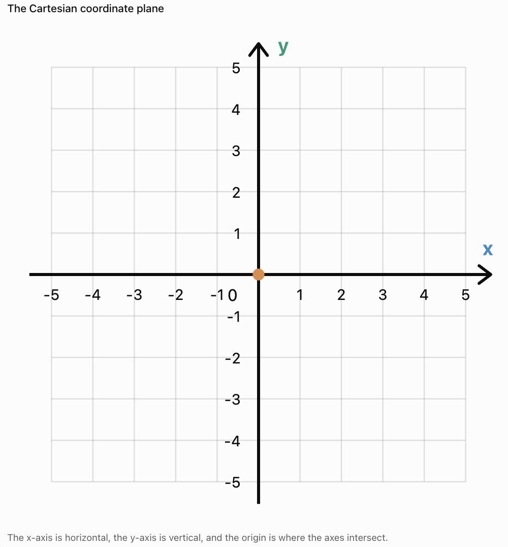
The coordinate plane is also called the Cartesian plane, named after the mathematician René Descartes.
The horizontal and vertical axes intersect at a point called the origin.
The origin has the coordinates:
(0, 0)
Important Features
-
Positive x-values are located to the right of the origin.
-
Negative x-values are located to the left of the origin.
-
Positive y-values are located above the origin.
-
Negative y-values are located below the origin.
Important Observation
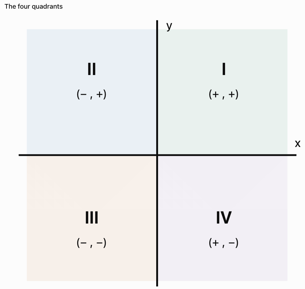
The axes divide the plane into four regions called quadrants.
The x-Axis
The x-axis is the horizontal number line on a coordinate plane.
It measures how far a point is positioned to the left or right of the origin.
Positive x-Coordinates
A positive x-coordinate indicates movement to the right.
For example:
x = 4
means four units to the right of the origin.
Negative x-Coordinates
A negative x-coordinate indicates movement to the left.
For example:
x = −3
means three units to the left of the origin.
Zero x-Coordinate
If x = 0, the point lies somewhere on the y-axis.
Important Observation
The x-coordinate describes horizontal position.
The y-Axis
The y-axis is the vertical number line on a coordinate plane.
It measures how far a point is positioned above or below the origin.
Positive y-Coordinates
A positive y-coordinate indicates movement upward.
For example:
y = 5
means five units above the origin.
Negative y-Coordinates
A negative y-coordinate indicates movement downward.
For example:
y = −2
means two units below the origin.
Zero y-Coordinate
If y = 0, the point lies somewhere on the x-axis.
Important Observation
The y-coordinate describes vertical position.
What Are Ordered Pairs?
A point on a coordinate plane is represented by an ordered pair.
An ordered pair contains two numbers written in parentheses:
(x, y)
The first number represents the x-coordinate.
The second number represents the y-coordinate.
Example
Consider the point:
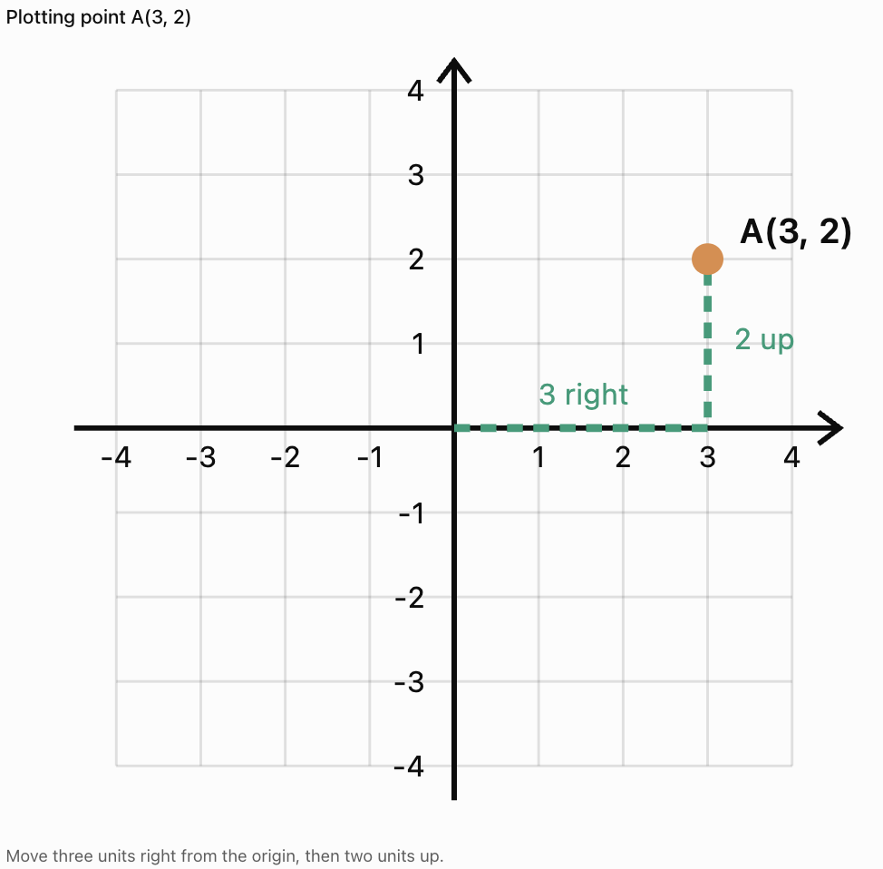
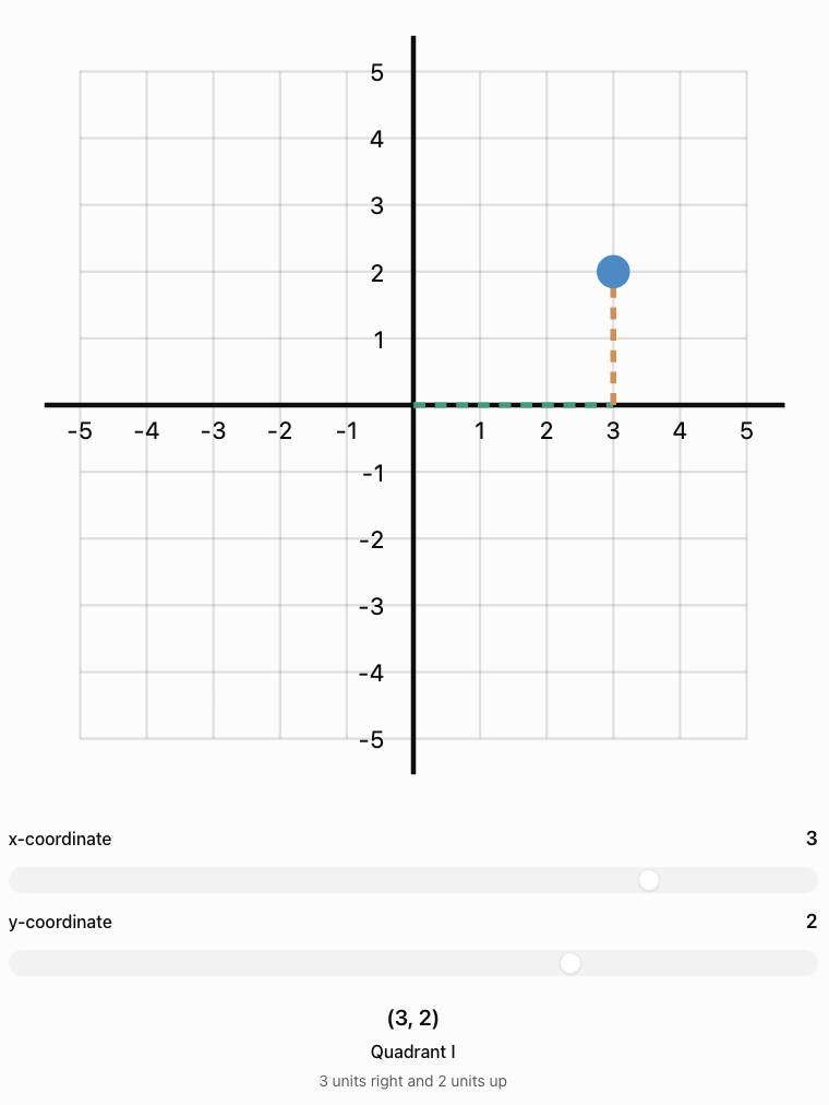
(3, 2)
This means:
-
Move 3 units to the right.
-
Move 2 units upward.
The point is located where these positions meet.
Remember
x first, y second.
A useful memory aid is:
Across first, then up or down.
Important Observation
The order of the numbers matters.
The points (3, 2) and (2, 3) are not the same location.
Plotting Points on the Coordinate Plane
To plot a point, begin at the origin.
Steps
-
Identify the x-coordinate.
-
Move horizontally according to the x-coordinate.
-
Identify the y-coordinate.
-
Move vertically according to the y-coordinate.
-
Mark the point.
-
Label the point if required.
Worked Example: Plotting (3, 2)
Important Observation
A point must be placed at the intersection of the correct vertical and horizontal grid lines.
Plotting Points with Negative Coordinates
Negative coordinates describe positions to the left or below the origin.
Example: Plotting (−4, 3)
Start at (0, 0).
-
Move 4 units left.
-
Move 3 units up.
-
Mark the point.
Example: Plotting (2, −3)
Start at (0, 0).
-
Move 2 units right.
-
Move 3 units down.
-
Mark the point.
Example: Plotting (−2, −4)
Start at (0, 0).
-
Move 2 units left.
-
Move 4 units down.
-
Mark the point.
The Four Quadrants
The coordinate plane is divided into four quadrants.
The quadrants are numbered counterclockwise, beginning in the upper-right region.
Quadrant Rules
|
Quadrant |
x-coordinate |
y-coordinate |
Example |
|---|---|---|---|
|
I |
Positive |
Positive |
(3, 4) |
|
II |
Negative |
Positive |
(−3, 4) |
|
III |
Negative |
Negative |
(−3, −4) |
|
IV |
Positive |
Negative |
(3, −4) |
Important Observation
Points lying directly on an axis do not belong to any quadrant.
Identifying the Quadrant of a Point
Worked Example
Determine the quadrant containing each point.
A = (4, 5)
B = (−2, 6)
C = (−3, −4)
D = (5, −2)
Solutions
-
A has positive x and positive y, so it lies in Quadrant I.
-
B has negative x and positive y, so it lies in Quadrant II.
-
C has negative x and negative y, so it lies in Quadrant III.
-
D has positive x and negative y, so it lies in Quadrant IV.
Important Observation
You can identify a quadrant using only the signs of the coordinates.
Points on the Axes
Not every point lies inside a quadrant.
Some points lie directly on the x-axis or y-axis.
Points on the x-Axis
Every point on the x-axis has:
y = 0
Examples:
(3, 0)
(−5, 0)
(0, 0)
Points on the y-Axis
Every point on the y-axis has:
x = 0
Examples:
(0, 4)
(0, −2)
(0, 0)
The Origin
The origin is:
(0, 0)
It lies on both axes.
Important Observation
The origin is not part of any quadrant.
Reading Coordinates from a Graph
Sometimes a graph shows a point, and we must determine its coordinates.
Method
-
Locate the point.
-
Read its horizontal position on the x-axis.
-
Read its vertical position on the y-axis.
-
Write the coordinates in the form (x, y).
Example
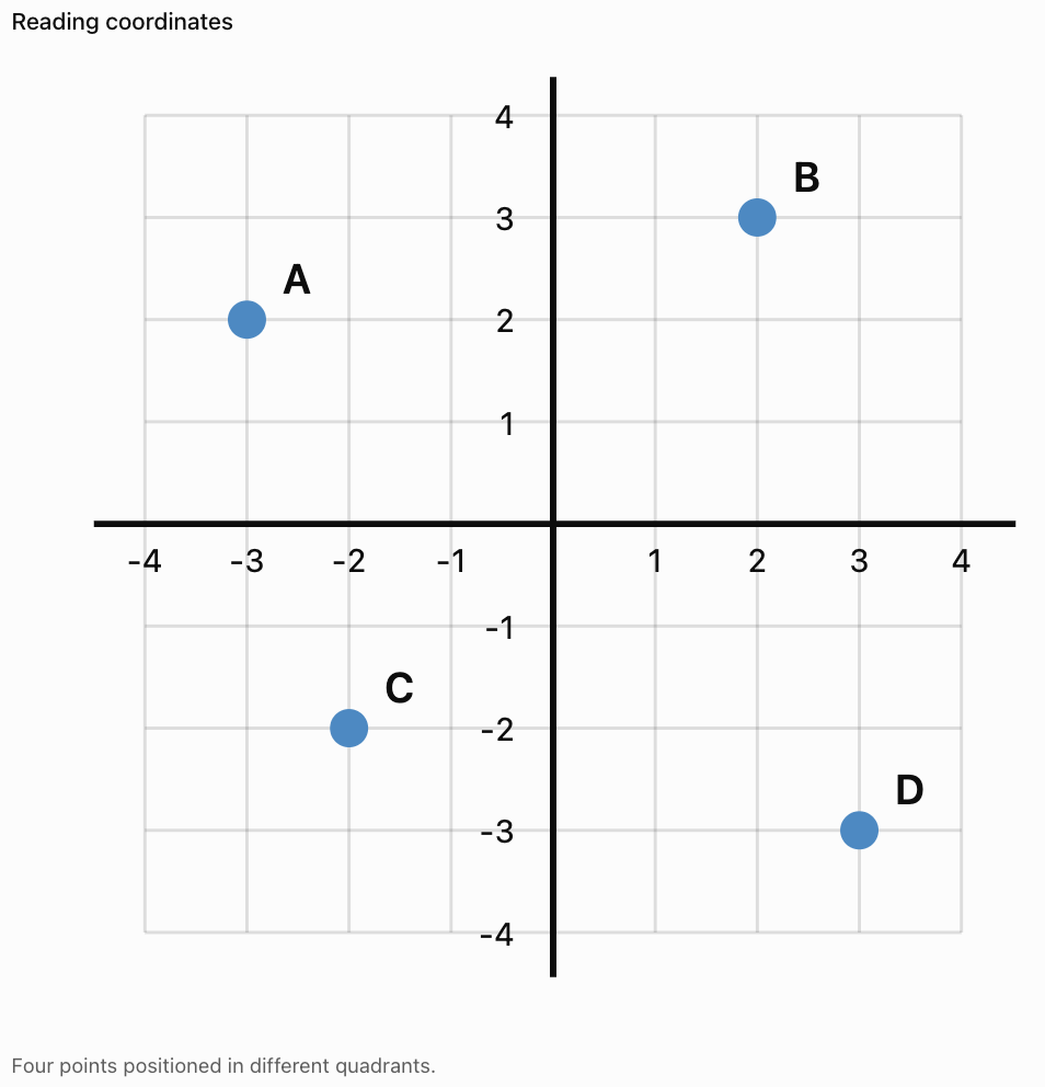
Answers
-
A = (−3, 2)
-
B = (2, 3)
-
C = (−2, −2)
-
D = (3, −3)
Important Observation
Always read the x-coordinate before the y-coordinate.
Describing the Location of Points
Coordinates allow us to describe locations precisely.
Example
Consider the point:
P = (−5, 2)
We can describe its position as:
"Point P is five units left of the origin and two units above it."
Another example:
Q = (4, −3)
"Point Q is four units right of the origin and three units below it."
Important Observation
Coordinate descriptions should include both horizontal and vertical position.
Comparing the Locations of Points
Coordinates also allow us to compare points.
Example
A = (2, 4)
B = (5, 4)
Both points have the same y-coordinate.
Therefore, they lie on the same horizontal line.
Point B is three units to the right of point A.
Another Example
C = (−3, 2)
D = (−3, −4)
Both points have the same x-coordinate.
Therefore, they lie on the same vertical line.
Point D is six units below point C.
Important Observation
-
Equal x-coordinates indicate vertical alignment.
-
Equal y-coordinates indicate horizontal alignment.
Horizontal and Vertical Distance
Coordinates can be used to calculate distances between points lying on the same horizontal or vertical line.
Horizontal Distance
If two points have the same y-coordinate:
Horizontal distance = |x₂ − x₁|
Worked Example
A = (−2, 3)
B = (5, 3)
Distance = |5 − (−2)|
Distance = |7|
Distance = 7 units
Vertical Distance
If two points have the same x-coordinate:
Vertical distance = |y₂ − y₁|
Worked Example
C = (4, −3)
D = (4, 5)
Distance = |5 − (−3)|
Distance = 8 units
Important Observation
Distance is always non-negative.
Drawing Shapes on a Coordinate Plane
Coordinate planes can be used to create geometric shapes.
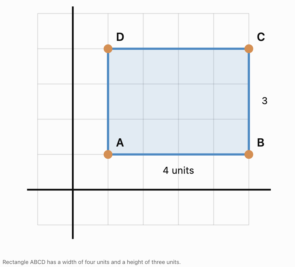
Example: Drawing a Rectangle
Plot the following points:
A = (1, 1)
B = (5, 1)
C = (5, 4)
D = (1, 4)
Connect the points in order:
A → B → C → D → A
Finding the Perimeter
Width = 5 − 1 = 4 units
Height = 4 − 1 = 3 units
Perimeter = 2(4 + 3)
Perimeter = 14 units
Finding the Area
Area = length × width
Area = 4 × 3
Area = 12 square units
Coordinate Planes in Maps
Coordinate systems are useful for locating objects on maps.

Example
A simplified map uses coordinates to identify locations.
-
School = (2, 3)
-
Library = (5, 3)
-
Park = (5, 6)
-
Sports Centre = (1, 6)
Questions
Which locations lie on the same horizontal line?
The school and library both have y = 3.
Which locations lie on the same vertical line?
The library and park both have x = 5.
Important Observation
Coordinate systems provide a precise way to describe locations without relying only on verbal directions.
Coordinate Planes in Computer Graphics
Computer graphics use coordinate systems to position objects on screens.

Examples include:
-
Video games.
-
Animation.
-
Graphic design.
-
Digital maps.
-
Computer-aided design.
Important Difference
In many computer screen coordinate systems, the origin is located in the upper-left corner.
The y-coordinate often increases downward rather than upward.
This is different from the usual mathematical coordinate plane.
Important Observation
Coordinate conventions must always be checked before interpreting positions.
Coordinate Planes in Physics
Coordinate systems are used to describe position and motion.

Example
A moving object begins at:
A = (0, 0)
It then moves to:
B = (4, 3)
Its horizontal displacement is:
Δx = 4 − 0 = 4 units
Its vertical displacement is:
Δy = 3 − 0 = 3 units
Important Observation
Coordinate systems allow scientists to describe movement in different directions.
Interactive Coordinate Practice
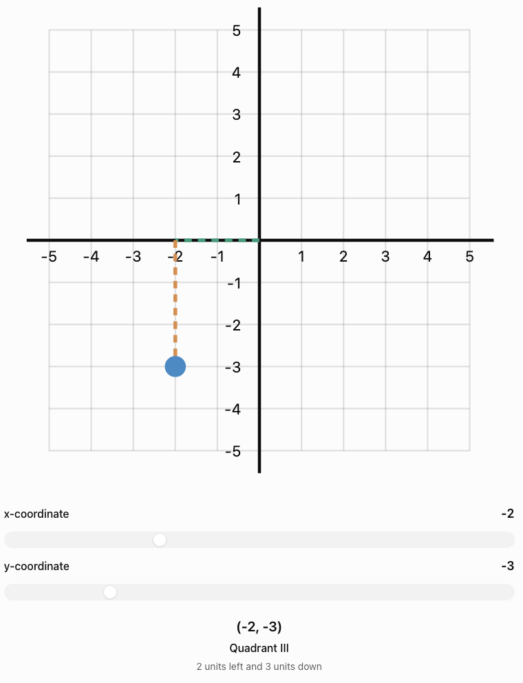
Use the sliders to move a point around the coordinate plane. Observe how its ordered pair and quadrant change.
Common Mistakes
Reversing the coordinates
The correct order is always (x, y).
Confusing the axes
The x-axis is horizontal; the y-axis is vertical.
Forgetting negative directions
Negative x-values move left; negative y-values move down.
Starting from the wrong location
Always begin plotting from the origin.
Counting grid lines incorrectly
Move the correct number of spaces or units, rather than counting the starting line as one unit.
Confusing quadrants
Quadrants are numbered counterclockwise, beginning in the upper-right region.
Placing points on the wrong axis
A point with y = 0 lies on the x-axis.
A point with x = 0 lies on the y-axis.
Assuming the origin belongs to a quadrant
The origin lies on both axes and belongs to no quadrant.
Ignoring the scale
Not all coordinate grids increase by one unit per square.
Confusing horizontal and vertical distance
Horizontal distance depends on x-coordinates; vertical distance depends on y-coordinates.
Key Terms
-
Coordinate Plane: Two-dimensional grid used to locate points.
-
Cartesian Plane: Another name for the coordinate plane.
-
x-Axis: Horizontal number line.
-
y-Axis: Vertical number line.
-
Origin: Intersection of the axes at (0, 0).
-
Ordered Pair: Two numbers representing a point's location, written (x, y).
-
x-Coordinate: First number in an ordered pair, indicating horizontal position.
-
y-Coordinate: Second number in an ordered pair, indicating vertical position.
-
Quadrant: One of the four regions formed by the axes.
-
Plot: Mark a point at its coordinates.
-
Point: Exact location on the coordinate plane.
-
Horizontal: Direction parallel to the x-axis.
-
Vertical: Direction parallel to the y-axis.
-
Positive Coordinate: Coordinate indicating rightward or upward position in the standard plane.
-
Negative Coordinate: Coordinate indicating leftward or downward position in the standard plane.
-
Coordinate Grid: Network of horizontal and vertical lines used to locate points.
-
Scale: Value represented by each interval on an axis.
-
Distance: Separation between two points.
-
Horizontal Distance: Difference between x-coordinates of horizontally aligned points.
-
Vertical Distance: Difference between y-coordinates of vertically aligned points.
-
Displacement: Change in position.
-
Quadrant I: Region with positive x and positive y.
-
Quadrant II: Region with negative x and positive y.
-
Quadrant III: Region with negative x and negative y.
-
Quadrant IV: Region with positive x and negative y.
Key Takeaways
-
A coordinate plane contains two perpendicular axes.
-
The x-axis is horizontal.
-
The y-axis is vertical.
-
The axes intersect at the origin (0, 0).
-
Points are represented using ordered pairs.
-
The x-coordinate is written first.
-
The y-coordinate is written second.
-
Positive x-values move right.
-
Negative x-values move left.
-
Positive y-values move up.
-
Negative y-values move down.
-
The coordinate plane has four quadrants.
-
Points on an axis do not belong to a quadrant.
-
Coordinates can be used to plot points and describe locations.
-
Equal x-coordinates indicate vertical alignment.
-
Equal y-coordinates indicate horizontal alignment.
-
Coordinate systems are useful in mathematics, science, navigation, and technology.
Check Your Understanding
Understanding the Coordinate Plane
-
What is the coordinate plane?
-
Which axis is horizontal?
-
Which axis is vertical?
-
What are the coordinates of the origin?
-
What is an ordered pair?
Plotting Points
-
Describe how to plot the point (3, 4).
-
Describe how to plot the point (−2, 5).
-
Describe how to plot the point (4, −3).
-
Describe how to plot the point (−3, −2).
-
Explain why (2, 5) and (5, 2) are different points.
Identifying Quadrants
-
Which quadrant contains (4, 6)?
-
Which quadrant contains (−3, 5)?
-
Which quadrant contains (−4, −2)?
-
Which quadrant contains (5, −3)?
-
Does the point (0, 4) belong to a quadrant?
Applying Coordinates
-
Two points are A = (2, 3) and B = (6, 3). Find the distance between them.
-
Two points are C = (−2, −3) and D = (−2, 4). Find the distance between them.
-
A point lies four units left and two units above the origin. What are its coordinates?
-
A point lies three units right and five units below the origin. What are its coordinates?
-
Explain how coordinates can be used to describe locations on a map.
Answer Key
|
Question |
Answer |
|---|---|
|
1 |
A two-dimensional grid formed by two perpendicular number lines |
|
2 |
x-axis |
|
3 |
y-axis |
|
4 |
(0, 0) |
|
5 |
A pair of numbers describing horizontal and vertical position |
|
6 |
Move 3 right and 4 up |
|
7 |
Move 2 left and 5 up |
|
8 |
Move 4 right and 3 down |
|
9 |
Move 3 left and 2 down |
|
10 |
The x- and y-coordinates are reversed |
|
11 |
Quadrant I |
|
12 |
Quadrant II |
|
13 |
Quadrant III |
|
14 |
Quadrant IV |
|
15 |
No; it lies on the y-axis |
|
16 |
4 units |
|
17 |
7 units |
|
18 |
(−4, 2) |
|
19 |
(3, −5) |
|
20 |
Each location is assigned a precise ordered pair |
Extended Challenge
1. Plot A = (−4, 3), B = (2, 3), C = (2, −2), and D = (−4, −2). Connect the points in order. What shape is formed?
2. Calculate the perimeter of the shape in Question 1.
3. Calculate the area of the shape in Question 1.
4. A point has a negative x-coordinate and positive y-coordinate. Which quadrant contains the point?
5. A point lies on the x-axis, seven units to the left of the origin. What are its coordinates?
6. A point lies on the y-axis, six units below the origin. What are its coordinates?
7. Two points are P = (−5, 4) and Q = (3, 4). Calculate the horizontal distance between them.
8. Two points are R = (2, −6) and S = (2, 5). Calculate the vertical distance between them.
9. A rectangle has vertices A = (1, 1), B = (6, 1), C = (6, 5), and D = (1, 5). Calculate its perimeter and area.
10. Explain why the points (−3, 4) and (3, −4) are not reflections across the x-axis or y-axis individually.
Extended Challenge Answers
|
Question |
Answer |
|---|---|
|
1 |
Rectangle |
|
2 |
22 units |
|
3 |
30 square units |
|
4 |
Quadrant II |
|
5 |
(−7, 0) |
|
6 |
(0, −6) |
|
7 |
8 units |
|
8 |
11 units |
|
9 |
Perimeter = 18 units; area = 20 square units |
|
10 |
Both coordinate signs change, corresponding to reflection through the origin |
Final Investigation: Designing a Coordinate Map
A school is creating a coordinate map of its campus.
The school places the origin at the centre of the campus.
The following locations are assigned coordinates:
|
Location |
Coordinates |
|---|---|
|
Main Building |
(0, 0) |
|
Library |
(4, 3) |
|
Science Building |
(−3, 4) |
|
Sports Centre |
(−4, −2) |
|
Cafeteria |
(3, −3) |
|
Bus Stop |
(0, −5) |
|
Garden |
(5, 0) |
Part A: Plotting the Map
-
Draw a coordinate plane from −6 to +6 on both axes.
-
Label the x-axis and y-axis.
-
Mark the origin.
-
Plot all seven locations.
-
Label each point clearly.
Part B: Describing Locations
-
Which location is at the origin?
-
Which location is in Quadrant I?
-
Which location is in Quadrant II?
-
Which location is in Quadrant III?
-
Which location is in Quadrant IV?
-
Which locations lie directly on an axis?
Part C: Comparing Positions
-
How far right of the origin is the library?
-
How far left of the origin is the Science Building?
-
How far below the origin is the Bus Stop?
-
Which location is farthest to the right?
-
Which location is farthest to the left?
Part D: Extending the Map
-
Add a new classroom at (−2, 2).
-
Add a new playground at (4, −4).
-
Describe the position of each new location relative to the origin.
-
Explain why coordinates are useful for creating accurate maps.
Investigation Answer Check
-
Main Building: Origin
-
Library: Quadrant I
-
Science Building: Quadrant II
-
Sports Centre: Quadrant III
-
Cafeteria: Quadrant IV
-
Bus Stop: Negative y-axis
-
Garden: Positive x-axis
-
Library: 4 units right of origin
-
Science Building: 3 units left of origin
-
Bus Stop: 5 units below origin
-
Farthest right: Garden
-
Farthest left: Sports Centre
-
New classroom: 2 units left and 2 units up
-
New playground: 4 units right and 4 units down
Final Reflection
The coordinate plane provides a simple but powerful method for describing locations.
By understanding the x-axis, y-axis, origin, ordered pairs, and quadrants, we can locate points precisely and interpret graphs accurately.
These skills form the foundation for graphing equations, studying geometric transformations, analysing motion, and solving many other mathematical problems.